File:Zuid-Holland position.svg
From Montepedia

Size of this PNG preview of this SVG file: 200 × 236 pixels. Other resolutions: 203 × 240 pixels | 407 × 480 pixels | 651 × 768 pixels | 868 × 1,024 pixels | 1,736 × 2,048 pixels.
Original file (SVG file, nominally 200 × 236 pixels, file size: 158 KB)
Summary
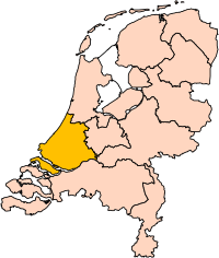
| Description | Location of the province of South-Holland (South Holland) in the Netherlands. |
| Date | |
| Source | Own work, based on freely available GIS data |
| Author | User:Mtcv |
| Permission (Reusing this file) |
Data: attribution required; my work: PD |
| Other versions | I attempted to make an svg version of Image:Zuid Holland-Position.png (with less simplified boundaries) |
Clickable version

Licensing

|
The copyright holder of this file, Centraal Bureau voor de Statistiek, allows anyone to use it for any purpose, provided that the copyright holder is properly attributed. Redistribution, derivative work, commercial use, and all other use is permitted. |
Attribution:
|
| Annotations | This image is annotated: View the annotations at Commons |


File history
Click on a date/time to view the file as it appeared at that time.
| Date/Time | Thumbnail | Dimensions | User | Comment | |
|---|---|---|---|---|---|
| current | 00:21, 3 March 2019 | | 200 × 236 (158 KB) | wikimediacommons>Thayts | update |
File usage
The following page uses this file:
